Create graphs of the azimuth, elevation and signal strength of all visible satellites using real-time data and visualize them in an easily accessible manner with information from several NMEA strings received from a USB GPS via emulated serial ports.
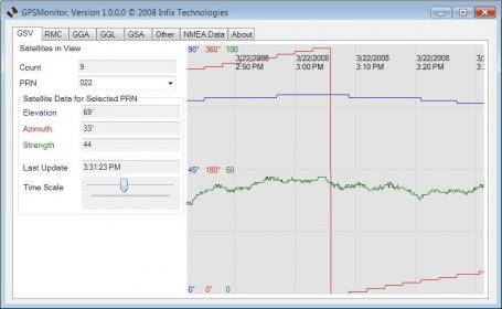
GPSMonitor graphs the azimuth, elevation and signal strength of all visible satellites, and displays human-readable data parsed from several types of NMEA string received from a USB GPS. The GPS uses an emulated serial port for communication running at 4800 baud. Graphed data is saved so it is visible when the program is run again later. It is able to show a Google map of your current location.
Parsed messages are:
GSV: Satellites in view.
RMC: Recommended minimum specific GPS/Transit data.
GGA: System fix data.
GLL: Geographic position, latitude and longitude.
GSA: Dilutioon of Precision (DOP) and active satellites.
More message types may be added based on user requests since many GPS models have different feature and message sets.

Comments (1)